Severe Thunderstorm Watch issued March 22 at 5:43PM EDT until March 23 at 12:00AM EDT by NWS Wilmington OH (details ...)
THE NATIONAL WEATHER SERVICE HAS ISSUED SEVERE THUNDERSTORM WATCH 73 IN EFFECT UNTIL MIDNIGHT EDT TONIGHT FOR THE FOLLOWING AREAS
IN INDIANA THIS WATCH INCLUDES 8 COUNTIES
IN EAST CENTRAL INDIANA
FAYETTE UNION WAYNE
IN SOUTHEAST INDIANA
DEARBORN FRANKLIN OHIO RIPLEY SWITZERLAND
IN KENTUCKY THIS WATCH INCLUDES 3 COUNTIES
IN NORTHERN KENTUCKY
BOONE CAMPBELL KENTON
IN OHIO THIS WATCH INCLUDES 32 COUNTIES
IN CENTRAL OHIO
DELAWARE FAIRFIELD FAYETTE FRANKLIN HOCKING LICKING MADISON PICKAWAY UNION
IN SOUTH CENTRAL OHIO
ADAMS HIGHLAND PIKE ROSS SCIOTO
IN SOUTHWEST OHIO
BROWN BUTLER CLERMONT CLINTON HAMILTON WARREN
IN WEST CENTRAL OHIO
AUGLAIZE CHAMPAIGN CLARK DARKE GREENE HARDIN LOGAN MERCER MIAMI MONTGOMERY PREBLE SHELBY
THIS INCLUDES THE CITIES OF ABERDEEN, ADA, ALEXANDRIA, AURORA, BATESVILLE, BEAVERCREEK, BELLEFONTAINE, BELLEVUE, BLANCHESTER, BRIGHT, BROOKVILLE, BURLINGTON, CAMDEN, CELINA, CHILLICOTHE, CIRCLEVILLE, COLDWATER, CONNERSVILLE, COVINGTON, DAY HEIGHTS, DAYTON, DELAWARE, DILLSBORO, DOWNTOWN CINCINNATI, DOWNTOWN COLUMBUS, DOWNTOWN DAYTON, EATON, ERLANGER, FAIRBORN, FAIRFIELD, FLORENCE, FORT THOMAS, FRANKLIN, GEORGETOWN, GREENDALE, GREENFIELD, GREENVILLE, HAMILTON, HIDDEN VALLEY, HIGHLAND HEIGHTS, HILLSBORO, INDEPENDENCE, KENTON, KETTERING, LANCASTER, LANDEN, LAWRENCEBURG, LEBANON, LIBERTY, LOGAN, LONDON, MANCHESTER, MARYSVILLE, MASON, MIDDLETOWN, MILAN, MILFORD, MINSTER, MOUNT CARMEL, MOUNT ORAB, MOUNT REPOSE, MULBERRY, NEW BREMEN, NEWARK, NEWPORT, OAKBROOK, OSGOOD, OXFORD, PEEBLES, PICKERINGTON, PIKE LAKE, PIKETON, PIQUA, PLAIN CITY, PORTSMOUTH, RICHMOND, RIPLEY, RISING SUN, SEAMAN, SIDNEY, SPRINGBORO, SPRINGFIELD, ST. MARYS, SUMMERSIDE, TIPP CITY, TROY, URBANA, VERSAILLES, VEVAY, WAPAKONETA, WASHINGTON COURT HOUSE, WAVERLY, WEST COLLEGE CORNER, WEST JEFFERSON, WEST UNION, WHEELERSBURG, WILMINGTON, WINCHESTER, WITHAMSVILLE, AND XENIA.
32° 32° Mon 47° Mon 47° 29° 29° Tue 53° Tue 53°
Monday, March 18th, 2024

Confirmed: Thursday's tornado hit 100 mph

From staff reports
Photo by Ryan Snyder/The Daily Standard

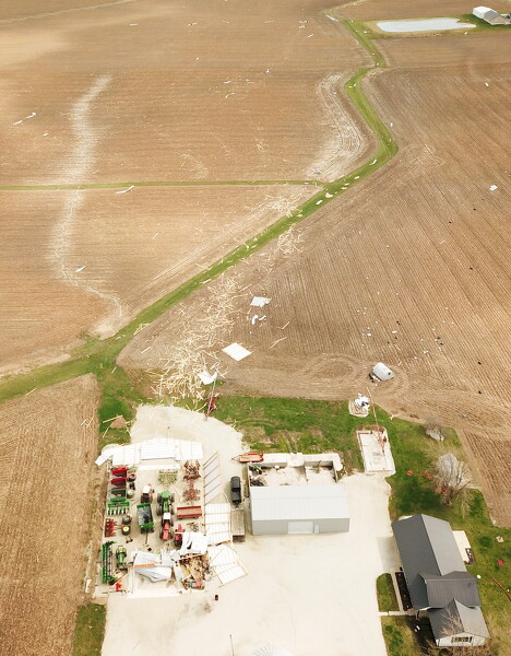
This machine shed on Burville Road was flattened by an EF1 tornado Thursday evening.

WILMINGTON - The tornado that hit Mercer County on Thursday measured EF1 with top wind speeds of 100 mph, according to the National Weather Service in Wilmington.

The tornado first touched down near New Corydon in Indiana at 6:40 p.m.

It moved east toward the state line and entered Mercer County at 6:45 p.m. along Skeels Road. A few properties south of the intersection of Skeels Road and State Route 49 suffered damage, according to a NWS report.

The tornado continued east along Carmel Church Road, causing damage to trees and outbuildings.

The report said the tornado came to the intersection of Carmel Church and Erastus Durbin roads, dipped southeast and caused damage to several homes along Mud Pike Road dissipating around 6:55 p.m.

Subscribe for $17/month

The NWS said the tornado cut a swath 8.6 miles long with a maximum width of 450 yards.

Subscriber and paid stories on this date
CHICKASAW - Councilors expressed support for a proposal to phase out a 3-mill property tax levy and also agreed to move forward with a proposal for a modest water rate increase.
COLUMBUS (AP) - Ohio's governor has declared a state of emergency in 11 counties across central Ohio struck by severe weather last week.
Gov. Mike
Girls State Basketball Tournament
Fort Loramie outscored Waterford 9-0 in the final 6 1/2 minutes of the first half to pull away and win the program's fourth Division IV state championship in winning 42-29 on Saturday afternoon at the University of Dayton Arena.