Severe Thunderstorm Warning issued March 22 at 9:27PM EDT until March 22 at 10:15PM EDT by NWS Wilmington OH (details ...)
SVRILN
The National Weather Service in Wilmington has issued a
* Severe Thunderstorm Warning for... Shelby County in west central Ohio... Northwestern Champaign County in west central Ohio... Western Logan County in west central Ohio... Darke County in west central Ohio... Southern Auglaize County in west central Ohio... Southeastern Mercer County in west central Ohio... Miami County in west central Ohio...
* Until 1015 PM EDT.
* At 927 PM EDT, severe thunderstorms were located along a line extending from near New Bremen to near Fountain City, moving east at 55 mph.
HAZARD...Quarter size hail.
SOURCE...Law enforcement.
IMPACT...Minor damage to vehicles is possible.
* Locations impacted include... Troy, Sidney, Piqua, Bellefontaine, Greenville, Tipp City, West Milton, New Bremen, Minster, Versailles, Covington, Arcanum, Newport, Bradford, Anna, Fort Loramie, Jackson Center, Russells Point, De Graff, and Pleasant Hill.
This includes I-75 in Ohio between mile markers 67 and 106.
Severe Thunderstorm Watch issued March 22 at 5:43PM EDT until March 23 at 12:00AM EDT by NWS Wilmington OH (details ...)
THE NATIONAL WEATHER SERVICE HAS ISSUED SEVERE THUNDERSTORM WATCH 73 IN EFFECT UNTIL MIDNIGHT EDT TONIGHT FOR THE FOLLOWING AREAS
IN INDIANA THIS WATCH INCLUDES 8 COUNTIES
IN EAST CENTRAL INDIANA
FAYETTE UNION WAYNE
IN SOUTHEAST INDIANA
DEARBORN FRANKLIN OHIO RIPLEY SWITZERLAND
IN KENTUCKY THIS WATCH INCLUDES 3 COUNTIES
IN NORTHERN KENTUCKY
BOONE CAMPBELL KENTON
IN OHIO THIS WATCH INCLUDES 32 COUNTIES
IN CENTRAL OHIO
DELAWARE FAIRFIELD FAYETTE FRANKLIN HOCKING LICKING MADISON PICKAWAY UNION
IN SOUTH CENTRAL OHIO
ADAMS HIGHLAND PIKE ROSS SCIOTO
IN SOUTHWEST OHIO
BROWN BUTLER CLERMONT CLINTON HAMILTON WARREN
IN WEST CENTRAL OHIO
AUGLAIZE CHAMPAIGN CLARK DARKE GREENE HARDIN LOGAN MERCER MIAMI MONTGOMERY PREBLE SHELBY
THIS INCLUDES THE CITIES OF ABERDEEN, ADA, ALEXANDRIA, AURORA, BATESVILLE, BEAVERCREEK, BELLEFONTAINE, BELLEVUE, BLANCHESTER, BRIGHT, BROOKVILLE, BURLINGTON, CAMDEN, CELINA, CHILLICOTHE, CIRCLEVILLE, COLDWATER, CONNERSVILLE, COVINGTON, DAY HEIGHTS, DAYTON, DELAWARE, DILLSBORO, DOWNTOWN CINCINNATI, DOWNTOWN COLUMBUS, DOWNTOWN DAYTON, EATON, ERLANGER, FAIRBORN, FAIRFIELD, FLORENCE, FORT THOMAS, FRANKLIN, GEORGETOWN, GREENDALE, GREENFIELD, GREENVILLE, HAMILTON, HIDDEN VALLEY, HIGHLAND HEIGHTS, HILLSBORO, INDEPENDENCE, KENTON, KETTERING, LANCASTER, LANDEN, LAWRENCEBURG, LEBANON, LIBERTY, LOGAN, LONDON, MANCHESTER, MARYSVILLE, MASON, MIDDLETOWN, MILAN, MILFORD, MINSTER, MOUNT CARMEL, MOUNT ORAB, MOUNT REPOSE, MULBERRY, NEW BREMEN, NEWARK, NEWPORT, OAKBROOK, OSGOOD, OXFORD, PEEBLES, PICKERINGTON, PIKE LAKE, PIKETON, PIQUA, PLAIN CITY, PORTSMOUTH, RICHMOND, RIPLEY, RISING SUN, SEAMAN, SIDNEY, SPRINGBORO, SPRINGFIELD, ST. MARYS, SUMMERSIDE, TIPP CITY, TROY, URBANA, VERSAILLES, VEVAY, WAPAKONETA, WASHINGTON COURT HOUSE, WAVERLY, WEST COLLEGE CORNER, WEST JEFFERSON, WEST UNION, WHEELERSBURG, WILMINGTON, WINCHESTER, WITHAMSVILLE, AND XENIA.
32° 32° Mon 47° Mon 47° 29° 29° Tue 53° Tue 53°
Saturday, October 13th, 2018
Photo by Ryan Snyder/The Daily Standard

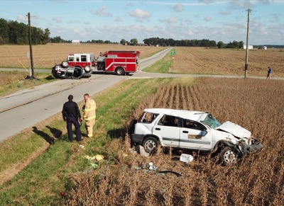
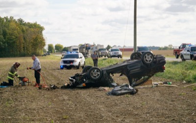
Lucas J. Jackson, 37, Toledo was driving an undisclosed vehicle at a high rate of speed on Hoenie Road south of Fast Road in Hopewell Township when he struck the rear of a 2001 Honda driven by an unnamed Celina man just after 10 a.m. Friday, according to a news release from the Mercer County Sheriff's Office.

Related online story:
A man involved in a two-vehicle collision on Friday morning stole a car belonging to a person who had stopped to help at the crash site and proceeded to lead police on a high-speed chase before crashing in a field along State Route 707. [More]
Additional pictures on this date