Severe Thunderstorm Watch issued March 22 at 5:43PM EDT until March 23 at 12:00AM EDT by NWS Wilmington OH (details ...)
THE NATIONAL WEATHER SERVICE HAS ISSUED SEVERE THUNDERSTORM WATCH 73 IN EFFECT UNTIL MIDNIGHT EDT TONIGHT FOR THE FOLLOWING AREAS
IN INDIANA THIS WATCH INCLUDES 8 COUNTIES
IN EAST CENTRAL INDIANA
FAYETTE UNION WAYNE
IN SOUTHEAST INDIANA
DEARBORN FRANKLIN OHIO RIPLEY SWITZERLAND
IN KENTUCKY THIS WATCH INCLUDES 3 COUNTIES
IN NORTHERN KENTUCKY
BOONE CAMPBELL KENTON
IN OHIO THIS WATCH INCLUDES 32 COUNTIES
IN CENTRAL OHIO
DELAWARE FAIRFIELD FAYETTE FRANKLIN HOCKING LICKING MADISON PICKAWAY UNION
IN SOUTH CENTRAL OHIO
ADAMS HIGHLAND PIKE ROSS SCIOTO
IN SOUTHWEST OHIO
BROWN BUTLER CLERMONT CLINTON HAMILTON WARREN
IN WEST CENTRAL OHIO
AUGLAIZE CHAMPAIGN CLARK DARKE GREENE HARDIN LOGAN MERCER MIAMI MONTGOMERY PREBLE SHELBY
THIS INCLUDES THE CITIES OF ABERDEEN, ADA, ALEXANDRIA, AURORA, BATESVILLE, BEAVERCREEK, BELLEFONTAINE, BELLEVUE, BLANCHESTER, BRIGHT, BROOKVILLE, BURLINGTON, CAMDEN, CELINA, CHILLICOTHE, CIRCLEVILLE, COLDWATER, CONNERSVILLE, COVINGTON, DAY HEIGHTS, DAYTON, DELAWARE, DILLSBORO, DOWNTOWN CINCINNATI, DOWNTOWN COLUMBUS, DOWNTOWN DAYTON, EATON, ERLANGER, FAIRBORN, FAIRFIELD, FLORENCE, FORT THOMAS, FRANKLIN, GEORGETOWN, GREENDALE, GREENFIELD, GREENVILLE, HAMILTON, HIDDEN VALLEY, HIGHLAND HEIGHTS, HILLSBORO, INDEPENDENCE, KENTON, KETTERING, LANCASTER, LANDEN, LAWRENCEBURG, LEBANON, LIBERTY, LOGAN, LONDON, MANCHESTER, MARYSVILLE, MASON, MIDDLETOWN, MILAN, MILFORD, MINSTER, MOUNT CARMEL, MOUNT ORAB, MOUNT REPOSE, MULBERRY, NEW BREMEN, NEWARK, NEWPORT, OAKBROOK, OSGOOD, OXFORD, PEEBLES, PICKERINGTON, PIKE LAKE, PIKETON, PIQUA, PLAIN CITY, PORTSMOUTH, RICHMOND, RIPLEY, RISING SUN, SEAMAN, SIDNEY, SPRINGBORO, SPRINGFIELD, ST. MARYS, SUMMERSIDE, TIPP CITY, TROY, URBANA, VERSAILLES, VEVAY, WAPAKONETA, WASHINGTON COURT HOUSE, WAVERLY, WEST COLLEGE CORNER, WEST JEFFERSON, WEST UNION, WHEELERSBURG, WILMINGTON, WINCHESTER, WITHAMSVILLE, AND XENIA.
32° 32° Mon 47° Mon 47° 29° 29° Tue 53° Tue 53°
Tuesday, July 16th, 2013

Weather heating up

By Shelley Grieshop
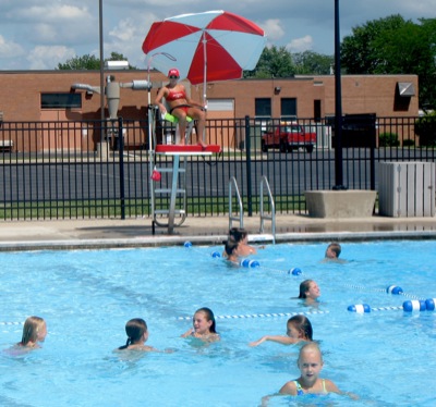
Photo by Margie Wuebker/The Daily Standard

Swimmers beat the heat Monday afternoon with lifeguard Nikki Borgerding keeping watch at the Minster Swimming Pool. Temperatures will stay in the 90s through Friday, local weather forecaster Dennis Howick reported.

It's hot ... get used to it.
High temperatures in the 90s and stifling humidity are predicted through Friday night, making the next four days the hottest yet this summer. The heat index likely will hit the three-digit mark, forecasters said.
"It's going to feel around 100 nearly every day," said Mike Kurz, a meteorologist for the National Weather Service.
The scorching and uncomfortable weather pattern is nothing new for Ohio this time of year.
"Into mid-July and early August is the hottest period for us," Kurz said, adding he's not expecting to break any heat records.
The temperature won't get above 100 most places because of the recent rainfall, he explained.
"We had a lot of precipitation in most places last week," he said. "That lingering moisture in the ground absorbs the heat so we won't get that warm."
Still, as temperatures climb and the high humidity coaxes sweat with minimal exertion, people of all ages need to take precautions, said Anne Larger, community outreach coordinator for Grand Lake Health Systems.
"Dehydration is the biggest problem," she noted.
The elderly, who tend not to drink enough fluids, and youngsters are most at risk, she explained.
"Babies dehydrate quickly," Larger, a registered nurse, added.
Heat exhaustion is evident when someone is sweating heavily, breathing rapidly and has a fast, weak pulse. It can be a precursor to a life-threatening heat stroke when a victim's body temperature rises above 105.1 degrees.
Symptoms of heat-related illnesses can include nausea, vomiting, diarrhea, fever and disorientation. Victims should seek medical attention immediately, Larger advised.
Precautions should be taken during all outdoor activities this week such as construction work and athletic practices. Wear light clothing, drink liquids often and wear sunscreen to prevent sunburn, medical experts say.
The muggy weather pattern is expected to change Friday evening when a cold front approaches from the north bringing lower temperatures and widespread showers and thunderstorms.
"You have a 50 percent chance of storms Friday into Saturday. Whenever you have such hot weather you have to expect the possibility of storms," Kurz said.
Highs and lows through Friday are in the 90s and 70s. Saturday's forecast includes a high of 85 with a 50 percent chance of showers.
Subscriber and paid stories on this date
Temporary fixes made until permanent solution found
CELINA - Several government agencies are working together this week to make short-term improvements to the deteriorating West Bank Road.
The Ohio d
ST. MARYS - The city expects to spend about $1.8 million more in 2014 than it anticipates it will pay out this year, according to the preliminary budget.
ACME District Tournament: Knights overcome 2-0 deficit to earn berth for state tournament
MINSTER - It was a bit of déjà vu for the Crestview ACME baseball team on Monday night.
For Minster, it was experiencing the same feeling St. Henry felt over 24 hours before.
Junior ACME
Coldwater's Junior ACME baseball team will play in the state tournament in Bryan this weekend after going 3-0 in the South Regional tournament held at Wapakoneta High School.