Cold Weather Advisory issued February 6 at 2:00AM EST until February 7 at 12:00PM EST by NWS Wilmington OH (details ...)
* WHAT...Very cold wind chills as low as 15 below zero expected.
* WHERE...Portions of east central Indiana and central, south central, southwest, and west central Ohio.
* WHEN...From 1 AM to noon EST Saturday.
* IMPACTS...The cold wind chills as low as 15 below zero could result in hypothermia if precautions are not taken.
Winter Weather Advisory issued February 6 at 1:54AM EST until February 6 at 6:00PM EST by NWS Wilmington OH (details ...)
* WHAT...Snow expected. Total snow accumulations between 2 and 3 inches.
* WHERE...Portions of east central Indiana, northeast and northern Kentucky, and central, south central, southwest, and west central Ohio.
* WHEN...From 6 AM this morning to 6 PM EST this evening.
* IMPACTS...Plan on slippery road conditions. The hazardous conditions could impact the Friday morning and evening commutes.
17° 17° chance slight chance Fri 34° Fri 34° light Sat 16° Sat 16°
Thursday, April 11th, 2013
Celina streets flood
Photo by Mark Pummell/The Daily Standard

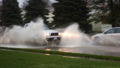
Wednesday's rain/hail deluge that dropped nearly an inch and a half of water in a short time caused minor street flooding in Celina, according to safety service director Tom Hitchcock. "We had a little bit of localized flooding, and the Beaver (Creek) is starting to rise, but it's not abnormal when we get a rainfall like last night," he said this morning. Hitchcock was unaware of any electrical outages, other than a little blink at approximately 3 p.m. In Auglaize County, Emergency Management Agency Directory Troy Anderson reported a few roads in the northeast section of the county were closed this morning due to flooding. Hail also was reported in the area. The National Weather Service forecast showers and thunderstorms today with some of the storms potentially producing heavy rain.

Additional pictures on this date