Flood Watch issued September 20 at 1:07PM EDT until September 21 at 8:00AM EDT by NWS Wilmington OH (details ...)
* WHAT...Flash flooding caused by excessive rainfall is possible.
* WHERE...Portions of Indiana, including the following counties, Dearborn, Fayette, Franklin, Ripley, Union and Wayne and Ohio, including the following counties, Adams, Auglaize, Brown, Butler, Champaign, Clark, Clermont, Clinton, Darke, Delaware, Fairfield, Fayette, Franklin, Greene, Hamilton, Hardin, Highland, Hocking, Licking, Logan, Madison, Mercer, Miami, Montgomery, Pickaway, Pike, Preble, Ross, Scioto, Shelby, Union and Warren.
* WHEN...From 7 PM EDT this evening through Monday morning.
* IMPACTS...Excessive runoff may result in flooding of rivers, creeks, streams, and other low-lying and flood-prone locations.
* ADDITIONAL DETAILS... - Showers and thunderstorms producing heavy rain will impact the area overnight. Rainfall totals of 1 to 3 inches are expected with locally higher amounts. The heavy rain combined with saturated ground will lead to potential flash flooding.
Flood Warning issued September 20 at 1:05PM EDT until September 21 at 8:00AM EDT by NWS Wilmington OH (details ...)
...Forecast flooding changed to Minor severity and increased in duration for the following rivers...
St. Marys River at Rockford.
* WHAT...Minor flooding is forecast.
* WHERE...St. Marys River at Rockford.
* WHEN...Until Monday morning.
* IMPACTS...At 13.0 feet, State Route 117 near Route 118 north of Rockford is water-covered and closed.
* ADDITIONAL DETAILS... - At 12:40 PM EDT Sunday the stage was 13.0 feet. - Forecast...The river is expected to rise to a crest of 13.0 feet this afternoon. It will then fall below flood stage just after midnight tonight. - Flood stage is 13.0 feet.
Today 80° Today 80° chance 61° 61° likely Tomorrow 66° Tomorrow 66° chance 58° 58° slight chance
Monday, December 13th, 2010

Road crews busy

Region records 4.2 inches of snow

By Shelley Grieshop
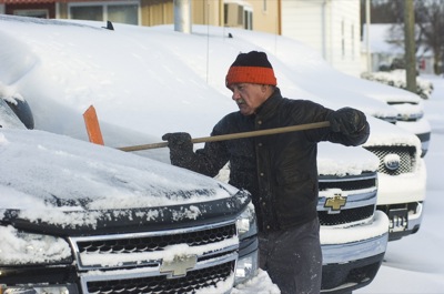
Photo by Mark Pummell/The Daily Standard

John Wycuff removes snow from a row of trucks this morning at Select Motors in Celina. More than four inches of snow were dumped on the Grand Lake area this weekend, according to local weather forecaster Dennis Howick.

Many snowblowers made their debut this weekend as the Grand Lake area was hit with more than four inches of snow.
The heavy, wet snow - accompanied by high winds and bitter cold - closed several area schools today and delayed classes at others because of the hazardous road conditions. As the sun peeked through at mid-morning, the wind remained an issue for road crews.
"We keep plowing it and the wind keeps blowing it back on the road," said Ron Leffel, transportation manager for the Ohio Department of Transportation in Auglaize County.
Leffel said his crews will continue 12-hour shifts indefinitely as they attempt to keep all state highways clear.
Mercer County Sheriff Jeff Grey on Sunday night issued a Level 1 snow alert warning motorists to use extreme caution on unincorporated state routes and county and township roads. The alert was canceled at 10 a.m. today.
Scattered flurries are expected to continue locally through Friday. High temperatures today and Tuesday will be about 20 with overnight wind chills of minus 2 degrees.
Other areas of Ohio were slammed with much more snow in recent days. Reports of more than 2 feet of snow were common in the northern and eastern portions of the state. And it's not over for them yet. The National Weather Service said parts of northeast Ohio could receive 2 feet or more of additional snow by Tuesday night.
Brad Laffin, road superintendent for Mercer County, said 12 snowplows were on the road by 4:30 a.m. today and will battle the elements until the job is done.
"There's a lot of blowing and drifting right now," he said this morning.
Layers of ice from the rain that fell on Saturday are mixed with packed snow. It's a nasty combination, Laffin said.
"It's very slick and it's supposed to blow most of the day. It's really going to hamper our efforts," he added.
On Sunday, the north and south roads were the worst. But as the wind direction changed overnight, every road became a problem, he said.
Law enforcement agencies in Mercer and Auglaize counties reported numerous vehicle slide-offs during the last 48 hours but no serious accidents as of this morning.
Sgt. Tom Brookhart of the Ohio State Highway Patrol post in Wapakoneta said the snowstorm's timing helped minimize crashes.
"A lot of it hit on Sunday when people really didn't have to leave home," he said.

Subscriber and paid stories on this date
FORT RECOVERY - Jim Vaughn loves Christmas.
With 300 Santa Claus objects, eight Christmas trees and more than 8,000 Christmas ornaments displayed in his country home outside of Fort Recovery, the retired dentist's fascination with the holiday is probably rivaled by few.
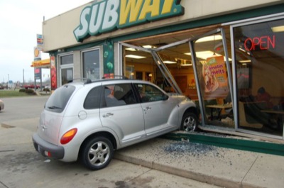
ST. MARYS - A local restaurant became a drive-thru business Saturday afternoon when an elderly motorist crashed through the wall.
No one was injured including the driver, Marjorie Shelby, 85, of St. Marys, according to the St. Marys Police Department.
MARIA STEIN - First-year Marion Local coach Mark DeLaney said before the season that he wanted to get out and run this season.
Saturday night at th
Weekend Roundup
Compiled by Gary R. Rasberry
The Coldwater Cavaliers, just a week after completing the football season, opened their boys basketball season on Saturday night and struggled against Van Wert in taking a 58-33 loss against the Cougars at the Palace.