Cold Weather Advisory issued February 6 at 2:00AM EST until February 7 at 12:00PM EST by NWS Wilmington OH (details ...)
* WHAT...Very cold wind chills as low as 15 below zero expected.
* WHERE...Portions of east central Indiana and central, south central, southwest, and west central Ohio.
* WHEN...From 1 AM to noon EST Saturday.
* IMPACTS...The cold wind chills as low as 15 below zero could result in hypothermia if precautions are not taken.
Winter Weather Advisory issued February 6 at 1:54AM EST until February 6 at 6:00PM EST by NWS Wilmington OH (details ...)
* WHAT...Snow expected. Total snow accumulations between 2 and 3 inches.
* WHERE...Portions of east central Indiana, northeast and northern Kentucky, and central, south central, southwest, and west central Ohio.
* WHEN...From 6 AM this morning to 6 PM EST this evening.
* IMPACTS...Plan on slippery road conditions. The hazardous conditions could impact the Friday morning and evening commutes.
17° 17° chance slight chance Fri 34° Fri 34° light Sat 16° Sat 16°
Tuesday, February 10th, 2009
Photo by Mark Pummell/The Daily Standard

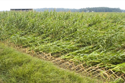
This Sept. 15 file photo of corn on Miller Road northwest of Celina shows corn downed by high winds that swept through Mercer County and other parts of the state on Sept. 14. The wind was the remains of Hurricane Ike, which heavily damaged the Galveston, Texas area. The worst corn damage in Mercer County appeared to be south of state Route 219, according to information from the Mercer County Farm Service Agency.

Additional pictures on this date