Flood Watch issued September 20 at 1:07PM EDT until September 21 at 8:00AM EDT by NWS Wilmington OH (details ...)
* WHAT...Flash flooding caused by excessive rainfall is possible.
* WHERE...Portions of Indiana, including the following counties, Dearborn, Fayette, Franklin, Ripley, Union and Wayne and Ohio, including the following counties, Adams, Auglaize, Brown, Butler, Champaign, Clark, Clermont, Clinton, Darke, Delaware, Fairfield, Fayette, Franklin, Greene, Hamilton, Hardin, Highland, Hocking, Licking, Logan, Madison, Mercer, Miami, Montgomery, Pickaway, Pike, Preble, Ross, Scioto, Shelby, Union and Warren.
* WHEN...From 7 PM EDT this evening through Monday morning.
* IMPACTS...Excessive runoff may result in flooding of rivers, creeks, streams, and other low-lying and flood-prone locations.
* ADDITIONAL DETAILS... - Showers and thunderstorms producing heavy rain will impact the area overnight. Rainfall totals of 1 to 3 inches are expected with locally higher amounts. The heavy rain combined with saturated ground will lead to potential flash flooding.
Flood Warning issued September 20 at 1:05PM EDT until September 21 at 8:00AM EDT by NWS Wilmington OH (details ...)
...Forecast flooding changed to Minor severity and increased in duration for the following rivers...
St. Marys River at Rockford.
* WHAT...Minor flooding is forecast.
* WHERE...St. Marys River at Rockford.
* WHEN...Until Monday morning.
* IMPACTS...At 13.0 feet, State Route 117 near Route 118 north of Rockford is water-covered and closed.
* ADDITIONAL DETAILS... - At 12:40 PM EDT Sunday the stage was 13.0 feet. - Forecast...The river is expected to rise to a crest of 13.0 feet this afternoon. It will then fall below flood stage just after midnight tonight. - Flood stage is 13.0 feet.
Today 80° Today 80° chance 61° 61° likely Tomorrow 66° Tomorrow 66° chance 58° 58° slight chance
Thursday, January 15th, 2009

Wind to make Grand Lake area feel like 30° BELOW

Frigid temperatures to remain through Friday

By William Kincaid
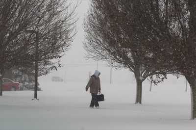
Photo by Mark Pummell/The Daily Standard

Local residents need to cover up, such as this person walking to the parking lot at the YMCA, as wind chill temperatures well below zero are predicted for today and Friday.

A frigid blast of snow and wind pummeled the Grand Lake area Wednesday, with dangerously cold temperatures expected today and Friday.
The low temperatures combined with west to northwest winds are expected to produce wind chills down to minus 30 degrees tonight. The National Weather Service has issued a wind chill warning until late Friday afternoon.
A low pressure system moved through the Midwest beginning Wednesday, with snow starting early in the morning, meteorologist Jim Loot of the National Weather Service in Wilmington said.
Nearly 5 inches of snow was reported as of this morning, with much of the heavy precipitation ending Wednesday afternoon, weather forecaster Dennis Howick of Celina said. A strong wind arrived behind this system.
"If at all possible, stay indoors," Loot warned.
If people must go outdoors, he recommended several layers of clothing, adding that all skin must be covered. During a wind chill warning, frost bite, hypothermia and death are possible if precautions are not taken, he said.
A nurse in the emergency department of Mercer County Community Hospital, Coldwater, said signs of frost bite include numbness and loss of sensitivity.
"I know people go to work, but cover up," she said.
Although she said she hasn't seen any cases of frost bite in a while, her department has treated many people for falls from the ice the last few weeks. The injuries included sprains, strains and broken bones.
At press time today, all local schools except New Bremen and Minster were closed because of the weather. Celina City Schools already announced a two-hour delay for Friday due to the cold temperatures.
Temperatures are expected to rise on Saturday to a high of 19 degrees.
Despite the subzero cold, no weather records were broken the last few days, Loot said. Howick said the area's record low is between negative 18 and 19 degrees.
Also, compared to the average three-month snow accumulation of 20 inches for November, December and January, Loot said Mercer and Auglaize counties are a few inches below that number. Howick reported 17 inches so far since November.

Additional online story on this date
Many energy providers consider the local area a prime center for large-scale wind and biomass energy projects, says the energy services director of the Ohio Farm Bureau Federation (OFBF). [More]
Subscriber and paid stories on this date
Mercer County commissioners are jumping into the real estate market with hopes of improving the value of a few local properties and neighborhoods.
MARIA STEIN - A long-distance friendship between two educators has sparked an opportunity for Marion Local Schools to join a select group of districts in the world offering a Mandarin Chinese language program called Confucius Classroom.
The only head coach the Parkway softball program has ever known will be paid the highest honor this weekend.
Mark Esselstein will be inducted into
The Celina Athletic Hall of Fame committee will be inducting its 2009 class on Saturday night between the jayvee and varsity boys basketball games against Toledo Rogers at the Fieldhouse.
Both teams are coming off a shorter week with Sunday wins. St. Henry beat Celina in the teams' first meeting since 1985 while the Blue Jays won their annual Sunday meeting with Lima Central Catholic at Arnzen Gymnasium.