Severe Thunderstorm Watch issued March 22 at 5:43PM EDT until March 23 at 12:00AM EDT by NWS Wilmington OH (details ...)
THE NATIONAL WEATHER SERVICE HAS ISSUED SEVERE THUNDERSTORM WATCH 73 IN EFFECT UNTIL MIDNIGHT EDT TONIGHT FOR THE FOLLOWING AREAS
IN INDIANA THIS WATCH INCLUDES 8 COUNTIES
IN EAST CENTRAL INDIANA
FAYETTE UNION WAYNE
IN SOUTHEAST INDIANA
DEARBORN FRANKLIN OHIO RIPLEY SWITZERLAND
IN KENTUCKY THIS WATCH INCLUDES 3 COUNTIES
IN NORTHERN KENTUCKY
BOONE CAMPBELL KENTON
IN OHIO THIS WATCH INCLUDES 32 COUNTIES
IN CENTRAL OHIO
DELAWARE FAIRFIELD FAYETTE FRANKLIN HOCKING LICKING MADISON PICKAWAY UNION
IN SOUTH CENTRAL OHIO
ADAMS HIGHLAND PIKE ROSS SCIOTO
IN SOUTHWEST OHIO
BROWN BUTLER CLERMONT CLINTON HAMILTON WARREN
IN WEST CENTRAL OHIO
AUGLAIZE CHAMPAIGN CLARK DARKE GREENE HARDIN LOGAN MERCER MIAMI MONTGOMERY PREBLE SHELBY
THIS INCLUDES THE CITIES OF ABERDEEN, ADA, ALEXANDRIA, AURORA, BATESVILLE, BEAVERCREEK, BELLEFONTAINE, BELLEVUE, BLANCHESTER, BRIGHT, BROOKVILLE, BURLINGTON, CAMDEN, CELINA, CHILLICOTHE, CIRCLEVILLE, COLDWATER, CONNERSVILLE, COVINGTON, DAY HEIGHTS, DAYTON, DELAWARE, DILLSBORO, DOWNTOWN CINCINNATI, DOWNTOWN COLUMBUS, DOWNTOWN DAYTON, EATON, ERLANGER, FAIRBORN, FAIRFIELD, FLORENCE, FORT THOMAS, FRANKLIN, GEORGETOWN, GREENDALE, GREENFIELD, GREENVILLE, HAMILTON, HIDDEN VALLEY, HIGHLAND HEIGHTS, HILLSBORO, INDEPENDENCE, KENTON, KETTERING, LANCASTER, LANDEN, LAWRENCEBURG, LEBANON, LIBERTY, LOGAN, LONDON, MANCHESTER, MARYSVILLE, MASON, MIDDLETOWN, MILAN, MILFORD, MINSTER, MOUNT CARMEL, MOUNT ORAB, MOUNT REPOSE, MULBERRY, NEW BREMEN, NEWARK, NEWPORT, OAKBROOK, OSGOOD, OXFORD, PEEBLES, PICKERINGTON, PIKE LAKE, PIKETON, PIQUA, PLAIN CITY, PORTSMOUTH, RICHMOND, RIPLEY, RISING SUN, SEAMAN, SIDNEY, SPRINGBORO, SPRINGFIELD, ST. MARYS, SUMMERSIDE, TIPP CITY, TROY, URBANA, VERSAILLES, VEVAY, WAPAKONETA, WASHINGTON COURT HOUSE, WAVERLY, WEST COLLEGE CORNER, WEST JEFFERSON, WEST UNION, WHEELERSBURG, WILMINGTON, WINCHESTER, WITHAMSVILLE, AND XENIA.
32° 32° Mon 47° Mon 47° 29° 29° Tue 53° Tue 53°
Tuesday, August 5th, 2008

Area farmers: keep on raining

By Betty Lawrence
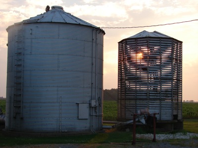
Photo by Janie Southard/The Daily Standard

Sunsets on Mercer County's agricultural landscapes are frequently picturesque even though they sometimes precede a nighttime storm as was the case on Monday.

The 1.05 inch of rain that fell overnight will help area crops, but more rain is needed, says local weather forecaster and farmer Dennis Howick.
"It was enough to help, but more is needed in another week," he said.
According to Howick, farmers need at least an inch of rain a week up until the first week in September to allow crops, especially corn, to fill out.
"Right now, corn is setting on ... and soybeans too are making grain right now and need the rain," he said.
Todd Mangen, educator at the local Ohio State University Extension office, said the area hasn't reached the critical level, but is headed that way.
He said the southern part of the county only got 0.03 inch of rain last night.
"Yes, we really need the rain now as the corn is pollinating and any rainfall right now will go a long way, as the crops are fully canopied, meaning it won't evaporate so fast," he said.
Showers are predicted for later today, followed by clearing and lower temperatures, paving the way for great weather conditions for the beginning of the Mercer County Banner Fair on Friday.
It has been an atrocious year for planting corn and soybeans, Howick said, noting some farmers were replanting up until the end of June due to wet weather during the planting season. Those farmers are praying for a late frost to allow time for the crops to grow, he said.
The overnight rainfall was accompanied by several rounds of thunder, lightning and wind, but not enough to cause damage, he said.
There were no reports of power outages in Mercer and Auglaize counties.
The barometric pressure this morning was low, contributing to uncomfortable conditions for people with allergies and sinus problems.
"For some reason, when there is a change in the barometric pressure, most people, including me, are affected when you go from a high pressure to low, rather than the opposite," Howick said.
Additional online story on this date
By BETTY LAWRENCE
and MARGIE WUEBKER
news dept@dailystandard.com
A Celina-area man pleaded no contest Monday morning in Celina Municipal Court to a charge of obstructing justice stemming from a March 15 traffic accident that claimed the lives of four local men. [More]
Subscriber and paid stories on this date
A flowering plant is full of blooms in the yard of Randy and Becky Myers, 4009 St. Anthony Road, Celina.
"The plant was given to us last spring an
ST. MARYS - Must dogs be on leash when walking in public areas of town, or not? That's been the ongoing discussion before city council's safety committee for the past few months - and so it continued at Monday night's meeting.
Eric B. Evers is located at local hospital after crash
Mercer County Sheriff's deputies did some searching after finding a wrecked motorcycle Saturday night and eventually found the driver undergoing treatment at an area hospital.
A local woman faces multiple charges in the wake of a traffic stop Monday night at Greenland Estates in Coldwater.
Coldwater Police pulled over a v
$150,000 available in Wabash River Watershed, $100,000 in Grand Lake
Producers have until Aug. 27 to sign up for the first round of ranking for $250,000 available this year to put conservation practices on their land.