Monday, July 16th, 2007
It's drought weather in the area now
By Janie Southard
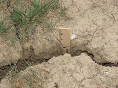
Photo by Janie Southard/The Daily Standard
How dry is it? Cracks in the ground merit measurement with a ruler. In many places you'll need one longer than 12 inches.
Local weather forecaster Dennis Howick reported the lack of rain this July is now below the amount recorded in July 1988, which was considered the area's worst drought year.
Howick's statistics show 0.12 of an inch of rain July 1-15, 1988, with the area receiving only 0.03 of an inch so far this July. The average rainfall for July is 4.43 inches.
Howick also reported the area has received 2.21 inches of rain this May and June, as compared to 2.08 inches during those months in 1988. This is more than 5 inches below the average rainfall for May and June of 7.49 inches.
Out in Grand Lake, boaters and other recreational water sport enthusiasts are keeping an eye on the lake level as it continues to fall.
"Oh, yes, it's below normal pool. However, it's been so windy we can't get a good reading," said Steve Dorsten of ODNR's Division of Water this morning. "Two weeks ago we were at normal pool."
The 50-foot notch at the top of the spillway indicates normal pool elevation.
Lack of rain this growing season is going to be a big disaster for farmers, said Howick, also a farmer.
"There's corn in the fields that will never get harvested," Howick said this morning, adding he believes the area east of Celina from state Route 703 north to Howick Road is the driest in the county.
"If we average 50 bushel an acre this year, we'll be doing good," he said. Normal average yield is about 175 bushels per acre.
Howick explained farmers have invested approximately $165 per acre in seed, fertilizer, chemicals, etc. Figuring $3.50 a bushel for corn and 50 bushels an acre, farmers will get about $10 an acre.
"And that doesn't count other expenses like labor, fuel, equipment, land ... Yes, it's going to be a bad year," Howick said. "Thank God for crop insurance."
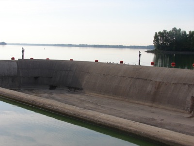
Photo by Janie Southard/The Daily Standard
Most things are water over the dam, but not this week. Nothing's moving over the West Bank Spillway except a bird or two on the wing.